CLIDATA GIS for ArcGIS
Introduction
CLIDATA GIS for ArcGIS 10 (ClidataGIS10) is special extension for GIS program ArcGIS 10. This extension allow to connect GIS program to climatological database (CLIDATA), creating GIS layers from data store in database, text files (CSV), interpolate point (station’s) data into surface, calculate area statistics and so on.
User manual
ClidataGIS10 has main toolbar
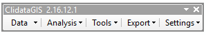
Submenus:
- Data
- Analysis
- Tools
- Export
- Settings
Data
This submenu is used for creating GIS point layer (type shapefile) from Clidata database or CSV files. There more predefined form for fast and simple create query to database like daily data, monthly data, normal data or more complex query by SQL .
RDATA
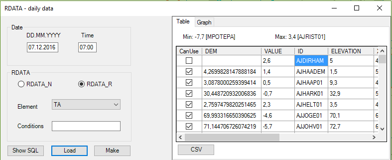
predefined form for getting data from Clidata tables RDATA_N (non regular data) and RDATA_R (regular data).
Where:
- Date is term which will be used for query to database
- Time for given Date and given Element
- Element selection of all elements which are defined in CLIDATA
- Table selection switch between RDATA_N and RDATA_R
- Conditions user defined additional SQL condition for query to database
- SQL for display generate SQL according to forms setting
- Load load data from database into table in this form
- Make convert all selected records in table (CanUse) into layer and show in map
- CSV export data from table into text file (format CSV)
- Table display loaded data in table form
- Graph display loaded data in chart, where X-axis is measure value, Y-axis stations altitude.

MDATA
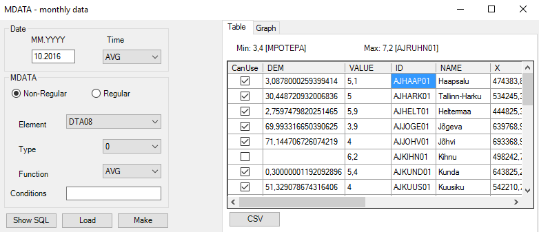 predefined form for getting calculated monthly data from Clidata tables MDATA (monthly data)
Where:
- Date is term which will be used for query to database
- Time for given Date and given Element
- Element selection of all elements which are defined in CLIDATA
- Non Regular switch to monthly calculations from non-regular data
- Regular switch to monthly calculations from regular data
- Type mean period for calculation (0-whole month, 1-1st decade, 2-2nd decade etc.(see MD_TYPE in Clidata manual)
- Function monthly calculation function (AVG, SUM, MIN, MAX). For more information see MD_FUNCTION in Clidata manual
- Conditions user defined additional SQL condition for query to database
- SQL for display generate SQL according to forms setting
- Load load data from database into table in this form
- Make convert all selected records in table (CanUse) into layer and show in map
- CSV export data from table into text file (format CSV)
- Table display loaded data in table form
- Graph display loaded data in chart, where X-axis is measure value, Y-axis stations altitude.
EDATA
 predefined form for getting calculated extreme data from Clidata table EDATA
Where:
- Date for which month you want to download data
- Time for given Date and given Element
- Element selection of all elements which are defined in CLIDATA
- Non Regular switch to monthly calculations from non-regular data
- Regular switch to monthly calculations from regular data
- Source which data source will be used (S standart , P provisory, F full)
- Conditions user defined additional SQL condition for query to database
- SQL for display generate SQL according to forms setting
- Load load data from database into table in this form
- Make convert all selected records in table (CanUse) into layer and show in map
- CSV export data from table into text file (format CSV)
- Table display loaded data in table form
- Graph display loaded data in chart, where X-axis is measure value, Y-axis stations altitude.
NDATA
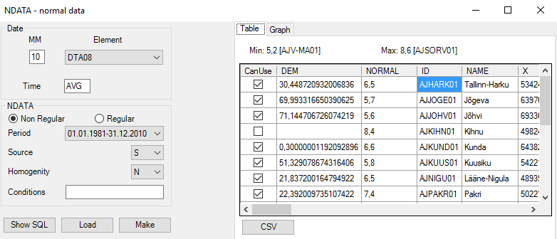
predefined form for getting calculated norma data from Clidata table NDATA
Where:
- Date MM is for month which will be used for query to database
- Time for given Date and given Element
- Element selection of all elements which are defined in CLIDATA
- Non Regular switch to monthly calculations from non-regular data
- Regular switch to monthly calculations from regular data
- Period which NDATA period will be used
- Source which source will be used (S standart, U user)
- Homogenity
- Conditions user defined additional SQL condition for query to database
- SQL for display generate SQL according to forms setting
- Load load data from database into table in this form
- Make convert all selected records in table (CanUse) into layer and show in map
- CSV export data from table into text file (format CSV)
- Table display loaded data in table form
- Graph display loaded data in chart, where X-axis is measure value, Y-axis stations altitude.
SQL

predefined form for getting data from Clidata by user’s defined SQL query
Where:
Query list of predefined SQL queries store in query directory
C:\ClidataGIS\AG\CLIDATA\query\*Description of given SQL query
- SQL user defined SQL query
- Save will save given SQL into query file in
C:\ClidataGIS\AG\CLIDATA\query\ - X Field name of field in given SQL which is used for X coordinate
- Y Field name of field in given SQL which is used for Y coordinate
- Value Field name of field in given SQL which is used for values
- Load load data from database into table in this form
- Make convert all selected records in table (CanUse) into layer and show in map
- CSV export data from table into text file (format CSV)
- Table display loaded data in table form
- Graph display loaded data in chart, where X-axis is measure value, Y-axis stations altitude.
CSV
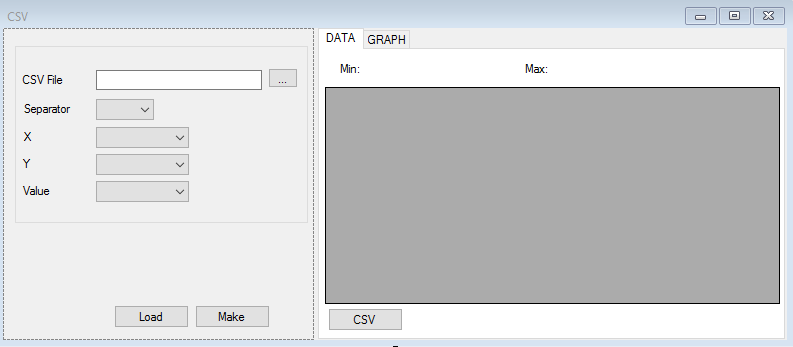
predefined form for getting data from text file (CSV file) separated by given separator
Where:
- CSV File CSV file
- Separator choose correct separator
- X field where are store X coordinates data
- Y field where are store Y coordinates data
- Value field where are store data
- Load load data from database into table in this form
- Make convert all selected records in table (CanUse) into layer and show in map
- CSV export data from table into text file (format CSV)
- Table display loaded data in table form
- Graph display loaded data in chart, where X-axis is measure value, Y-axis stations altitude.
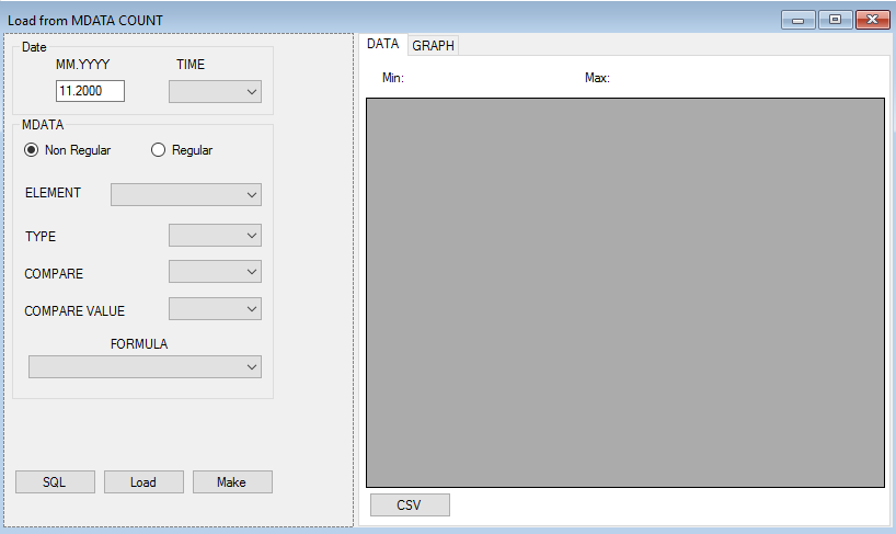
Mdata Count * not implemented yet
WindData * not implemented yet

Analysis
This submenu is used for statial analysis like spatial interpolations or area statistics on interpolated layer.
Interpolation
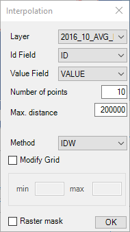
This function is used for spatial interpolation from point layer (station’s meteorological data) into surface (grid). User can select one of predefined interpolation methods IDW, LLR, Clidata Dem) for more detail see document “Interpolation methods in ClidataGIS”
Where:
- Layer name of point layer which will be used as source for interpolation
- Id Field name of field where are store station’s identifications (gh_id, eg_gh_id etc)
- Value Field name of field, where are store values for interpolation
- Number of points of stations in surrounding used for interpolation. Default value is 10 stations in surrounding
- Max. distance maximum distance for searching stations
- Method interpolation method used for interpolation.
There are these methods defined:
* IDW: Inverse distance weighted * LLR: Local linear regression (elevation) * Clidata DEM: Modified local linear regression - Modify grid possibility for change min, max value of calculate raster layer
- Min interpolate values lower than min will change to min value
- Max interpolate values higher than max will change to max value
- Mask interpolate raster layer will masked by mask raster file
c:\ClidataGIS\AG\CLIDATA\DEM\mask.asc
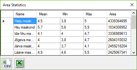
Area Statistics

This function is used in case you want calculate average, minimal and maximal values in a given region (polygon) layer. Example: I want to calculate average altitude in my country border layer
Where:
- Raster name of raster layer which will be used as source for calculation
- Layer name of polygon layer used like Areas
- Group Field name of field, which will be used for grouping (field Name in result table)
- Calculate will calculate area statistics (mean,min,max) values in area defined in polygon layer from surface defined in Raster
- Result will display calculated result in new table
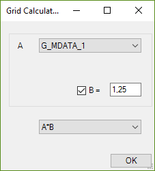
Grid Calculator
Tool is used for do math operation between two raster layer
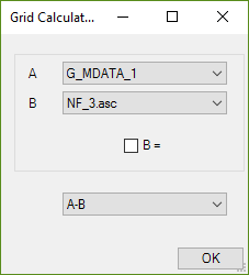
Or
Do math operation with one raster layer and some constant
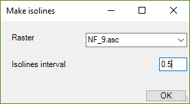
Isolines
Tool is used for make isolines from selected raster layer. User have to select from which raster layer want do isolines and set interval between isolines
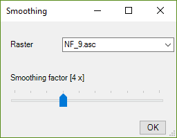
Smoothing
Tool is used for make smooth operation for selected raster layer. Factor mean how many times this process will be repeat.
Cut raster
Tool is used for cut selected raster layer with selected one feature polygon layer

Tools
Load Legend
For active raster layer user can download predefined raster legends stored in Clidata database
Export
Export map to PNG
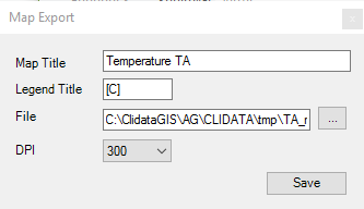
Used can export map into image file in format PNG by using this tool. Where:
- Map Title is title for your map
- Legend Title is title in legend of raster legend like [C°]
- File is filename for your map in PNG format
- DPI is resolution for image file
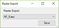
Export to Raster
Tool will export selected raster layer into Erdas Imagine format .img with symbology layer .lyr into user's defined directory
Settings
User can in this part to define area for clipping display in map and in case user can define different DEM (digital elevation model ) than default.
Cancel Clip Geometry
Tool cancel user defined geometry for clipping map frame
Set Terrain
User can change default (DEM\dem.asc) digital elevation model to your own. DEM file have to be in ascii grid format (*.asc)
Set Frame Clip
User can choose for active polygon layer geometry by click on map, which will be used for clipping map frame